MORE THAN A PATHWAY?
City showcases RiverLine trail project plan
CITY OF NAPA
Ziplining, underwater tunnels, public art — Napa’s latest pedestrian and bicycle trail project wrapping around the west side of the Napa River has the potential to become far more than a picturesque path.
Napa city officials on Saturday afternoon hosted an open house at CIA at Copia to ask residents what they want out of a 4.3-mile riverside trail proposal called Napa RiverLine. The pathway would span from Tannery Bend north to Trancas Crossing Park, most notably framing the outskirts of the Oxbow district.
Brendan Hurley, the city’s economic development coordinator and leader of the RiverLine project, said at the open house the trailway is intended to become a public amenity aimed both at locals and tourists that would “activate the river.”


“This project is setting the stage for future investment to improve these areas (of the riverbank) that have fallen in,” Hurley said.
The city’s economic development division earlier shared unveiled plans for the RiverLine to the City Council on Dec. 17. Staff said that project is intended to open up access to the Napa River, and added that the trail is inspired by other famous riverside walking paths, namely New York City’s High Line, a former elevated railroad on the West Side of Manhattan.
At the Napa open house, Hurley clarified that this project is separate from the city’s flood wall project, which is managed by Napa County’s Flood Control & Water Conservation District. With that said, Hurley noted the RiverLine will use current and future segments of the flood wall to inform its pathway.
“Thinking about how we can integrate with the flood wall in the future is key, but they’re completely different projects,” he said.
According to the city’s consultant partner SWA, project director Alison Ecker said the path and all its potential amenities will take roughly 20 years to finish.
The city gave Napans a chance to speak out on how they would like the trail to look and feel, what kind of public art they would want there, what kind of activities they would like to see included, and how they think the project should be funded.
Many ideas, both ambitious and practical, were presented to residents. These included adding a wildlife observation deck, an underwater tunnel viewing area, zip lines across the river, meditation pavilions and environmental art, as well as other amenities.
Throngs of people stopped by the four-hour forum, including people of all ages and with different ways of relating to their hometown river.
Jason Harmon, rear commodore of the Napa Valley Yacht Club, liked the idea of being able to walk onto a protected path and get to downtown from his neighborhood.
“As a part of the yacht club, it’s going to connect my community, my family, with the rest of the city,” Harmon said.
According to a map of the trail presented at the open house, the pathway would begin on the west side of the Napa River and pass through the yacht club, at the south end of Riverside Drive.
Blake Schmitz, 9, said she likes to fish and walk along the river currently, but there were a few ideas that caught her eye.
“I would want to go zip lining a lot,” said Blake. “I’ve only been zip lining at a park before. That would be fun.”
Amenities along the trail
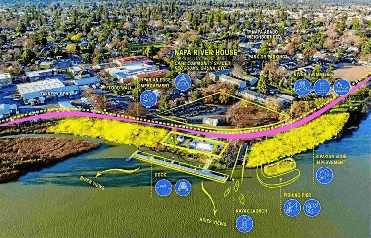
Outside of outdoor activities, Napa officials also are interested in creating a core area of the trail that would feature a bike hub for cyclists, a “river house,” and a pedestrian bridge linking the Napa river’s banks.
The RiverLine would intersect with the 47-mile Napa Valley Vine Trail envisioned to run from Vallejo to Calistoga. In graphics shown to open house attendees, the city and its consultants envisioned a potential hub at the corner of Soscol Avenue and First Street. The hub could include a cafe, outdoor seating and bike parking.
Kara Vernor, executive director of the Napa County Bicycle Coalition, said that although the group favors more connections with the Vine Trail and restoring the existing Napa River Trail, which would become apart of the project, the idea of a bike hub was slightly concerning.
“What concerns us is whether or not the core piece is being envisioned as a bike path,” she said. “They’re talking about it a lot as a pedestrian path, but this (Napa River trail) is a bike path.”
The pathway would be divided into three sectors: north, core and south. According to a graphic presented to Napans on Saturday, RiverLine North would begin at Trancas Crossing Park, then flow into the RiverLine core encompassing the Oxbow District and downtown. The core, in turn, would lead into RiverLine South, starting at Division Street and ending at the Maxwell Bridge, which carries Imola Avenue and Highway 121 over the Napa River.
Ecker said the core area will be more focused on retail and amenities, while the other segments will be more traditional nature paths.
The city also garnered feedback on the creation of a “River House” that would serve as another community meeting place, possibly a cafe, recreation rooms and sauna. In graphics presented by the consultant group, the house was shown with a fishing pier, dock and kayak launch.
Site options for the River House include using the yacht club site or the vacant land next to the Maxwell Bridge.
Additionally, the city seeks to create a bridge for pedestrians to get from one side of the Napa River to the other. One potential location would connect the Oxbow Commons to the existing promenade that runs from behind Downtown Joe’s brewpub and Veterans Memorial Park south to Napa’s Riverfront.
According to the project’s website, an interactive pedestrian path has been in the works since 2005, though planning for the RiverLine planning began only last June.
Source: https://napavalleyregister.com/more-than-a-pathway/article_6fe7125b-40e8-53b0-bd07-6071d8493cb5.html